Expanded Kurdistan claim
 A few days ago the Kurds unveiled an expanded Kurdish region which they want enshrined as an appendix to the new constitution. As I understand it the claim represents not simply areas which currently have a majority Kurdish population, but areas which they believe did so at some point in the past 50-100 years.
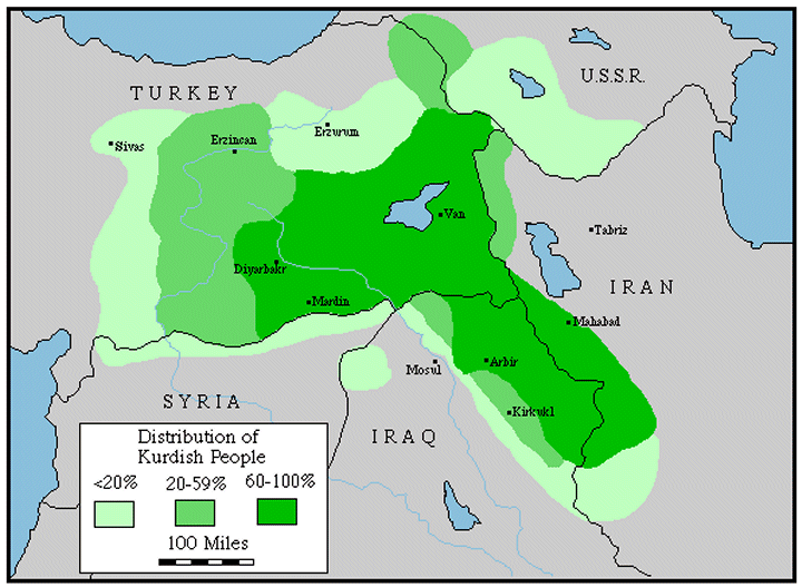
I'm afraid I only have this low resolution photo of the map which is confusing as it changes the boundaries of the existing Kurdish governorates while adding in new regions. I've drawn in a red line which roughly represents the current boundary of the existing Kurdistan Regional Government region (Dohuk - the top brown region, Erbil - the central green region and Sulimaniya - the brown region on the right).
Working from top left to bottom right: A chunk of Nineveh governorate has been added to Dohuk (the brown area below the red line, and another large section of Nineveh is coloured as a new (mid-green) goverorate including Sinjar and part of Mosul, I think just skirting the large Turkoman city Tel Afar. The whole of Tam'im governorate (with Kirkuk at the centre) has been included with parts of Diyala, Salahadin and Sulymania added to produce the large dark green region. A large slice of Diyala along the border has been marked as a sixth region (light green) and finally a chunk of Wasit (including the towns of Badra and Jassan) is the seventh and smallest region in the expanded Kurdistan. In all this would represent a doubling of the Kurdish region and include areas which currently have majority arab, chaldo-assyrian and turkoman populations.
For some background, here is a Google image search for maps of Kurdistan. Some of the most ambitious mark out a region reaching to the Meditaranian, Black Sea, Caspian Sea and the Gulf. Edinburgh University has an interesting linguistic map which matches reasonably well with the most detailed map on kurdistania.com. There are excellent summary maps on Globalsecurity.org showing past claims and autonomous regions and a rough guide to the Kurdish percentage of the population in different areas on Globalsecurity.org.
P.S. In case you haven't heard the good news, Khalid Jarrar is now free, after 10 days of interrogation. Sadly he had to shave his beautiful beard which seems to have been the main reason for his arrest. He'll promises he'll write about his ordeal shortly.
![]()
3 comments:
justin,
you could cite the source of the map... me & "niqash"... and yes - the map is on our site.
I'm so happy to hear Khalid is free although it is tragic that he could be detained in the first place. I'm so happy that blogs like this one exist so that we in the US can get an accurate view of the situation in Iraq, untainted by politics and fear.
-Linnea
Dear Mathias Klein-
Justin does cite the source of the map: it is himself. He had access to it and posted it online. Furthermore, I just visited your site, and though I can tell that it is quite well-funded, it wasn't easy to find the map. In fact, I couldn't find it on your site.
In any case, I don't understand your tone of ownership over what is now a publicly displayed map.
Post a Comment